
Leaving the beautiful Lake Louise and travelling north towards Jasper, our tour guide Nancy soon announced that we were going to call into a lookout which would give us a stunning view of Peyto Lake, from which the headwaters of the magnificent Bow River occurs. Travelling in Europe a few years ago we recall a fellow tourist, pointing to a fine looking building on a hill in a nearby village, asking “What is that?”, and the guide replying, “ABC”. “ABC?” “Another bloody church”, replied the guide, and indeed, that is just what it was, so many fine churches had we already seen.
So it is in Canada, but the temptation here is to eventually regard the fine sights surrounding you as just another bloody river, another bloody mountain, or another bloody lake.
Peyto Lake was certainly not ‘just another lake’, however. Like Lake Louise, the lake we had just come from, it was picture perfect, an amazing azure and aquamarine blue, and set like a jewel in its surrounds of valley and forests. It reminded us of the Lakes district in England, such was its balance and the sense of “rightness” within its surrounds that is conveyed to those who view it. Such was the beauty of the scene from this lookout it is very popular and usually quite crowded. However, thanks to our very competent driver and tour guide, we arrived in the early morning before the hordes, and were able to take a little time to appreciate this sight, and take a couple of photos that we hope go some way to communicating the beauty of Peyto Lake.


Peyto Lake
From there, as we headed again towards Jasper, we were once again surrounded on all sides by breathtakingly beautiful, magnificent mountains and vast pine-filled valleys. The Icefields Parkway from Banff to Jasper must surely be one of the most stunning stretches of roadway in the world. We were lucky enough to travel this route in bright sunshine. At one point our bus stopped on the highway, amongst much other traffic, as workers blasted rock from the high cliffs on the edge of the road, in an effort to prevent dangerous rock falls in the future, and then cleared the debris from the road. At other points were told that in winter the army is brought in to fire explosive charges into the deep snow high on those mountains which traverse the highways, to avoid potentially catastrophic avalanches plunging down the mountainside into traffic. On every mountain you can see the pathways of previous rockslides, as they apparently take the same routes down mountains when they occur. Occasionally large ‘sheds’ (for want of a better description) are built over roads and railways along these rockslide routes, enabling the tumbling rock to simply slide harmlessly above the road or rail line and continue down the valley. Traffic flows can then continue and no one gets hurt. Such is the ingenuity of humans when figuring out how to live with dangerous natural forces.
As you drive along the valley floors throughout the Canadian Rockies one can see any number of glaciers high up in the mountain valleys, hanging over the crests of the high mountain ridges. These are impressive, but a long way away, and one cannot fully appreciate their majesty. On this leg of our trip, however, a highlight has been to actually walk on one of these monstrous glaciers, the Athabasca Glacier, and see it first hand.
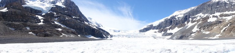
The Athabasca Glacier comprises part of the huge Columbia Ice Field, the largest ice field in the Rockies, which stretches for 120 kilometres along the top of the Continental Divide between the provinces of British Columbia and Alberta. From below the glacier, visitors are driven up onto the surface of the glacier by huge, soft-tyred snow coaches, which can accommodate 40 passengers and have been built especially to enable this form of experience to occur. Our vehicle, sort of like a large Mars Rover, drove us slowly and carefully down the steep sides of the lateral moraine which borders the glacier. Our driver was, of course, an Aussie from the Sunshine Coast! The point where we were deposited on the glacier was perhaps one kilometre from its downward edge, but well up above the tree line, and even here, on a relatively low point on the glacier, the ice is 200 metres thick.
The scale of this glacier is hard to comprehend. As we approached it in our touring bus the snow coaches on its surface looked like grains of coffee, and the people each as small as a pin head. When you stand on its surface it is cold, and windy, and exposed, and our guide explained that people cannot survive for long in such a hostile environment without specialist knowledge and equipment. Because the glacier can contain hidden holes and ravines, we were asked to stay within a designated safety area, and so we did (occasionally tourists who did not obey this requirement have died, having fallen into a crevasse they did not see).


Images of the Athabasca Glacier
The bulk of the glacier hovered over us, kilometres away, much thicker and more imposing than the huge tailing deep ice sheet on which we stood. Surrounding us on the high peaks on both sides were higher, more monstrous arms of deep ice and snow, white and pristine and awe-inspiring. Jenny took a photo of her feet standing on the glacier, proof that she had been there. It has definitely been one of the highlights of the tour so far.
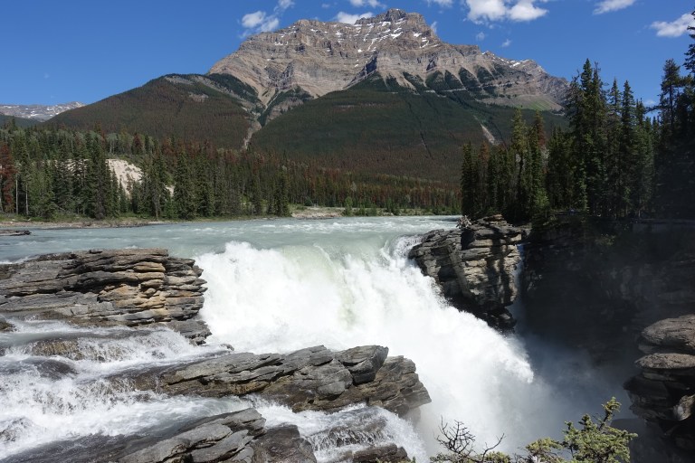
Following this we stopped in at the Athabasca Falls, just south of Jasper. The falls are not so high, coming in at about 25 metres, but it is the volume and the power of the water that surges over these falls that is impressive.
Finally, we arrived in the town of Jasper. What a pretty little town, situated in the Jasper National Park in the Rockies about 290 km north of Banff. Our accommodation was the Fairmont Jasper Park Lodge, nestled gorgeously on the shores of a lovely little lake within Jasper National Park. Walking along the shores of the lake we saw squirrels and chipmunks, and along the edges of the resort observed herds of elk grazing in the great sea within the thinly-treed woods.
At Jasper we took a ride on Harley Davidson motorcycle! Jenny had never been on a motorbike, and Steve only once or twice. Donning our allocated leathers, we feel we looked quite the part of the scowling, non-conformist biker of popular culture. The only trouble is, when it came to the official photo, our lovely (sorry, cool and disdainful!) driver Rob told us we had to smile, not scowl, as we had to look like we were enjoying ourselves! So we did smile, but took a few on our own camera where we tried to look cool, careless and lawless. We don’t think it worked, at least not for Steve. Jenny looks pretty cool, though.
Rob took us on his bike out to the ‘Meeting of the Waters’, the junction of the Athabasca and Whirlpool rivers, which was an extraordinarily beautiful place as these two aqua-green and quickly flowing rivers joined. This was an old crossing for the pioneering fur traders who came into this region centuries ago, and standing there you could picture them emerging out of the thick and often damp forest on the river banks, pack horses in tow, as they made their way to town to sell their furs.


Coming back into Jasper on our bike we marvelled at the amazingly broad valley that confronted us, it’s slopes stretching away up to the borders of the Rocky Mountain range and thickly carpeted with beautiful green pine trees. We have nothing like this in Australia, and we are glad to have had the opportunity to experience this.
From Jasper we began to head back to the South-west, in the general direction of Vancouver. However before we stopped for the day at our next accommodation at Sun Peaks we called into a couple of very interesting spots.
Maligne Canyon is found not far out of Jasper, and is the deepest river canyon in the Rockies. It features a number of walking trails which border the Maligne River as it rushes down the canyon it has created, eating into the limestone rock and carving an amazing, narrow, deep gorge (at points over 50 metres deep). The sound of the water rushing is ever present, but just a little distance away from the rushing and pounding of the water as it charges through the canyon, a sense of peace and tranquility emerges as you stop to observe the wild Alberta Rose which grows along the canyon’s edges. Various colours of moss add texture to the other senses you experience at the canyon. This was a great little stop on our way towards Sun Peaks. The canyon was very deep and narrow, but Jenny overcame her fear of heights to be able to cross several small bridges across the chasm (another big tick for Jen).
On our way from Maligne Canyon to the highlight of this days activities, the River Safari at Blue River, we stopped for a morning hot chocolate just below Mt Robson, (3,954 metres), the highest mountain in the Canadian Rockies. We couldn’t see its summit, of course, shrouded as it was in clouds and mists, but from what we could see of its lower reaches it looks massive and magnificent. Apparently it is quite a rare occasion to see the summit of Mt Robson, so we were not Robinson Crusoe. Mt Robson, by the way, while Canada’s highest mountain in the Rockies, is not Canada’s highest mountain. This honour belongs to Mt Logan, high up in the Yukon, at 5,959 metres (over 20,000 feet).
The Blue River Safari on the way to Sun Peaks was billed as our best opportunity to see bears, even though most of us on the tour had already seen at least one or two bears up until this point. The safari is a boat ride upstream on the Blue River. Our luck with the weather, however, finally ran out and, as rain started to fall just as we were departing the dock, and in no time at all it was pouring. Despite this, and the fact that we saw no bears, motoring silently upstream into this wilderness area was an unexpectedly enjoyable experience, and a sober reminder of the courage the first settlers must have had to forge their way into these foreign and hostile wilderness areas.
We stayed overnight at the ski resort town of Sun Peaks (a very pretty little village and ski resort but with great infrastructure and quickly becoming a favourite and the ‘new Whistler’). We had dinner with a couple who had been to Sun Peaks before, in the skiing season. They showed us photos of trees up on the highest slopes here in the middle of winter, when it was -20 degrees. These trees were completely frozen in blocks of ice, such is the harshness of the winter climate. Amazingly, these trees survive until spring when they thaw out to once again create the circle of life, thriving and seeding new trees. These pine trees across the Rockies are so hardy, not only surviving the harsh cold, but clinging to, and growing on, the sides of sheer cliffs all over the mountains. No wonder they are so dominant in this landscape.
Leaving Sun Peaks, we headed towards the much larger and more established ski resort town of Whistler where we eventually arrived in the late afternoon. Instead of driving to the north and west, our driver Brian was forced to head down the southern route, and then west towards Vancouver, before turning north up past Vancouver and then on to Whistler – a much more indirect route. The problem was a landslide that had blocked the highway on the intended route and no traffic could get through.

Whistler was crowded and buzzing. Despite being summer, skiing is still possible in Whistler’s back country until October. The main reason for the activity though was the fact that on July 1st it is Canada Day and a long weekend to boot, and we were to spend Canada Day in Whistler. We joined the many people from the town and the thousands who had come up for the weekend and observed the Canada Day celebrations. This was very interesting. Canadians seem to be very proud of their tolerant multicultural society and shared values. While there, we were treated to breakfast and a tour at the Squamish Lil’Wat Cultural Centre.


Images from the Squamish Lil’Wat Cultural Centre
To get to our last stop, the city of Victoria on Vancouver Island, our bus took a 90 minute ferry ride from the mainland, north of Vancouver. Vancouver Island is very pretty and its largest city, Victoria, is also the capital city of the province of British Columbia. This was news to us, as we had simply assumed the capital was Vancouver, the largest city.
Victoria is a lovely city, set on the harbour, as was our hotel. While there we took several trips on the small, very cute water taxis which traverse the harbour – a great way to get around! Our highlights here were: firstly to visit the renowned Butchart Gardens – absolutely stunning gardens created more than one hundred years ago by a pioneering industrialist family with a vision to turn waste land into something special. It is still in the hands of that family, who have tended and extended it with love and dedication, and it is simply the best and most beautiful gardens we have ever walked through. Words cannot convey the feelings of beauty, peace and tranquility one experiences here, even amongst the many other tourists drawn to these gardens. Beautiful, beautiful, beautiful!
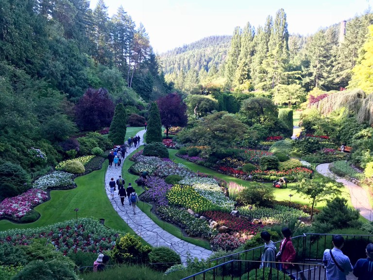


Views of the amazing Butchart Gardens in Victoria, BC
Our second excursion was to take a boat out to go whale watching. The local whales here are mainly Orcas, the killer whales, but alas we saw none of these today although they are common both inside and outside of Victoria Harbour. We did however, see a Humpback whale, which is the same species we see when we go whale watching off our home in Queensland Australia. We also saw seals, a sea otter, and a magnificent bald eagle, sitting majestically on a rocky outcrop in the middle of the ocean – a fitting finale, in our mind, to an exciting and exhilarating two and a half weeks in the natural beauty that is western Canada and the Canadian Rockies.
Tomorrow we travel from Victoria back to Vancouver to pick up a cruise ship, on which we will visit Alaska and its wonders, travelling the inside passage. We are not likely to have great internet then, and so our next post, on that segment of our trip, will be in another week or so.
